The long-awaited arrival of public transit support is finally here for iOS 9. For people who do not have cars or simply would like to move around town via public transit, this is a huge improvement. Instead of looking up each mode of public transportation individually, Transit in Maps is the only place you need to go to get all the public routes you’ll need.
How to use transit directions in Maps in iOS 9
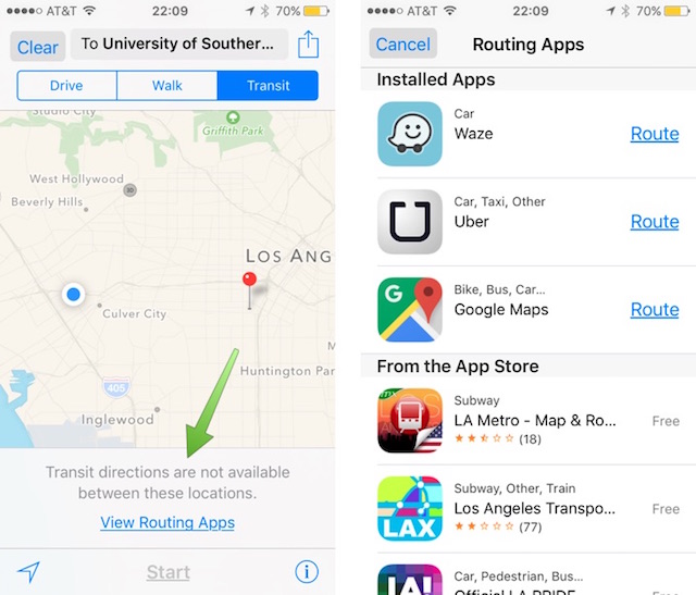
Before we begin, it should be noted that Transit directions are currently only available in select cities. For example, Los Angeles is a very popular city, but it does not currently have support in Transit. So, if this turns out to be the case for you, you’ll see this message, “Transit directions are not available between these two locations.” You can then choose, View Routing Apps to find other options that may reveal a public route.

Step 1.
First, open up Maps on your iDevice. Since I know New York City has support for Transit, I am going to use that location in my example. With Maps open, put in the locations you are leaving and arriving. Then tap Route. I am traveling from Times Square to Ellis Island Museum. I know, super touristy.

Step 2.
By default, the route will be shown as if you are driving. Tap on the Transit tab near the top of the screen to view the possible public transit options.

Step 3.
Tap Start to begin routing your trip. Each of the steps will be laid out onto separate cards, just how they would for driving or walking directions. You can tap on the list icon in the bottom center, to view the upcoming steps or stations.

As an added helper, the different segments of the trip each have their own unique color on the Map. This will help people recognize when to switch public transportation services at a quick glance.

Step 4.
If you are unsure of exactly where you are supposed to go on the Map, you can use the 3D map and zoom to find entrances to subways or bus stops. Tap on the Info icon and select 3D map from the menu. This 3D view makes it a lot easier to understand your surroundings and getter better grasp on the buildings along your path. You can zoom and rotate the map to drill in on a specific location or path by using your thumb and index finger.

Sadly, there is no flyover support for Transit at this time. But you can go back and use the Driving or Walking directions tab to quickly enable flyover for a more life-like preview of your route. Again, tap on the Info icon and choose 3D map and Satellite.

Transit will make it a lot easier for folks to get around some of the world’s most popular cities. While the supported list of cities is currently quite small and contains mostly major cities, like London, San Francisco, and Chicago, Apple will surely continue to add cities to that list.
Let us know what you think of Transit inside Apple Maps in the comment section.
Check out the iOS 9 page for our comprehensive coverage of all the new and hidden iOS 9 features.